A Glossary of Colorado Climbing and Peakbagging Terms
Inclusion criteria for summits on 100summits.com is somewhat different than other lists on the web. I realize that there is no accepted standard for defining a summit, in fact, Wikipedia suggests that "there is no universally-accepted definition of a mountain. Elevation, volume, relief, steepness, spacing and continuity has been used as criteria for defining a mountain." The Oxford English dictionary defines a mountain as "a natural elevation of the earth surface rising more or less abruptly from the surrounding level and attaining an altitude which, relatively to the adjacent elevation, is impressive or notable." Many sites (Vulgarian Ramblers, ListsofJohn, etc.) use the rule that the summit must have 300' of topographical prominence in order to be considered a mountain. While this metric is very good at distinguishing summits from false summits, it fails to recognize summits that are clearly summit-worthy, or have other features that would lure a person to want to climb or hike to the top of it. Many names of summits are found on the USGS maps. Those summits that are not found on USGS maps are either provided with nicknames given by local mountaineers, or they are designated by the prefix "UN" followed by the elevation of the summit.
Elevation is simply the height of the summit above sea level, in feet or meters. All data shown in the table is in feet; however, the elevation for each summit in meters can be found in the details page of each summit. Elevations are generally shown on each USGS 7.5 minute quadrangle for each summit. When elevations are not shown on the map, they are interpolated by looking at the closest contour line to the summit.
A summit in Colorado is defined as ranked if it rises at least 300' above saddles to higher summits (also known as topographical prominence). Summits in Colorado have been ranked this way for many years, and the 300' rule has been widely accepted by the mountaineering community as a very effective and arbitrary way to rank Colorado's summits. An "S" designation or "Soft Rank" means the summit could qualify as a ranked summit if extrapolated elevations were not used for the summit and/or interpolated elevations were not used to determine the elevation of the Prominence Saddle. When summits have the same elevation, ranking is determined in the following order: (1) Elevation, (2) Prominence, (3) Isolation, and lastly (4) alphabetically. A green checkmark indicates that the summit is ranked, while a red "X" indicates that the summit is not ranked.
The Prominence of a summit is its rise above the highest saddle connecting the summit to higher ground, otherwise known as the Prominence Saddle. In other words, the Prominence of a summit is it's height above the lowest contour line encircling it and no higher summit. Prominence is the elevation of the summit minus the elevation of the Prominence Saddle. Given elevations in a saddle are used, but only if they represent the low point of the saddle. Many climbers rate mountains solely based on its Prominence, rather than its elevation. If you personally feel that Prominence is the most important feature of a summit, you can filter the summit table to show the most prominent peaks in Colorado. On the summit table, Prominence is shown in feet; however, the detailed view of the summit also shows the Promience in meters. Wikipedia.org provides this great diagram, visually explaining Prominence:
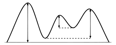
Vertical arrows show the Prominence of three peaks on an island. A dotted horizontal line links each peak (except the highest) to its Prominence Saddle.
The Promience Saddle is the low point of the highest connecting ridge to an elevation greater than the summit's maximum elevation. When multiple saddles are present but not on the same connecting ridge, the Prominence Saddle is selected by determining which saddle has the shortest distance to a line parent.
Spire Measure or Omnidirectional relief and steepness (ORS) is an absolutely brilliant concept that was developed jointly by David Metzler and Edward Earl. David Metzler graciously and laboriously provided all of the ORS data for every single summit in the 100summits.com database. ORS is a purely objective summit measure which takes into account how high the peak rises above local terrain, and how steeply. Since it is a local measure it does not take absolute elevation into account, only the relative height of the summit above its surroundings. So for example a lot of the Colorado Fourteeners get low ratings, since many of them are not very steep and rise from high bases. Also, it is an omnidirectional measure, so it averages out how steep a peak is in all directions. Hence something like El Capitan in California gets a pretty decent rating, but not as much as if it were a spire which was sheer in all directions. Hence the old name "spire measure"; while something does not have to look like a spire to get a decent spire measure, the more a peak is shaped like a big, steep pointy spire, the higher its spire measure will be. However ORS measures any landscape feature, not just spires; hence the name ORS. Learn more about the theory behind the ORS measurement.
ORS thus roughly measures the visual "impressiveness" of a summit, since peaks which rise high and steeply above their surroundings tend to be the most visually impressive. ORS also acts as a very rough measure of how difficult a peak is to climb, since it factors in steepness and height. However there are many other factors which determine how impressive a peak looks (a subjective notion, after all) and how hard a peak is to climb. It is important that ORS is not claimed to match any particular person's notion of impressiveness or climbing desirability.
It should also be noted that the ORS data for summits on 100summits.com does not factor in the fact that a summit could very well be a sub-peak of another summit, which can significantly reduce the ORS score of a summit. In fact, David Metzler has created another measurement that factors in the degree of independence a summit has from a larger, more impressive summit that it is adjacent to. This measurement is called Reduced Omnidirectional relief and steepness (RORS). Roughly, this measurement takes the spire measure of the summit in question and subtracts off a piece for each nearby better peak, based on how close together they are.
Lastly, it should also be noted that oftentimes the best ORS point is not a peak (i.e. it has little or no prominence). Hence making a peak list using prominence as a cutoff and then ranking the resulting list using ORS can be misleading, as it can totally miss some of the best features. An example of this is the Black Canyon of the Gunnison. This issue comes up frequently for a fair number of summits, where the best spot to measure ORS is not exactly at the true summit. For example, Longs Peak would score much higher in ORS if the measurement were taken closer to the steepest face as opposed to the actual summit. In those cases the true summit value is an underestimate of the quality of the peak
The Class of a summit refers to its subjective rating on the Yosemite Decimal System (YDS). A summit's Class is a measure of the difficulty of a peak in terms of climbing skills required, without regard to duration of the climb or the duration of the difficulty. The Class listed indicates the easiest ascent possible for the particular summit. By adding the summit as one you have climbed, you can designate your own Class rating based on the route you used to reach the summit. It should also be noted that a summit's Class is based by the hardest move on the route taken. For example, if a summit is very easy except for the summit block, where there is a 5.8 move, the route would be rated 5.8. The specific classes are defined by Wikipedia as follows:
- Class 1: Walking with a low chance of injury.
- Class 2: Simple scrambling, with the possibility of occasional use of the hands. Little potential danger is encountered.
- Class 3: Scrambling with increased exposure. A rope can be carried but is usually not required. Falls are not always fatal.
- Class 4: Simple climbing, with exposure. A rope is often used. Natural protection can be easily found. Falls may well be fatal.
- Class 5: Technical free climbing involving rope, belaying, and other protection hardware for safety. Un-roped falls can result in severe injury or death.
Class 5 is subdivided even further, ranging from 5.0 to 5.13.
In Mountaineering, Freedom of the Hills, author Ed Peters explains the subdivisions of class 5:
"The experienced climber, having accomplished or attempted free climbs of varying degrees of difficulty in the YDS class 5 range, gains an understanding of the level of difficulty involved. To the beginner, however, these ratings are simply a set of numbers, understandably, easy if rated 5.0 and impossible if rated 5.13. To provide a slightly better understanding within the class for the beginner the following tongue-in-cheek description is provided:
- 5.0 to 5.4: There are two hand- and two footholds for every move; the holds become progressively smaller as the number increases.
- 5.5 to 5.6: The two hand- and two footholds are there, obvious to the experienced, but not necessarily so to the beginner.
- 5.7: The move is missing one hand- or foothold.
- 5.8: The move is missing two holds of the four, or missing only one but is very strenuous.
- 5.9: The move has only one reasonable hold which may be for either a foot or a hand.
- 5.10: No hand- or footholds. The choices are to pretend a hold is there, pray a lot, or go home.
- 5.11: After thorough inspection you conclude this move is obviously impossible; however, occasionally someone actually accomplishes it. Since there is nothing for a handhold, grab it with both hands.
- 5.12: The surface is as smooth as glass and vertical. No one has really ever made this move, although a few claim they have.
- 5.13: This is identical to 5.12 except it is located under overhanging rock.
RJ Secor defines the classes bluntly:
- Class 1: you fall, you're stupid.
- Class 2: you fall, you break your arm.
- Class 3: you fall, you break your leg.
- Class 4: you fall, you are almost dead (i.e., you can't breath and move your arms, legs, and head).
- Class 5: you fall, you are dead.
Before one can fully understand Interpolation, it is helpful to understand how topographical maps graphically represent data through the use of contour lines. A contour line is a line that connects points of equal elevation. The contour line traces the outline of the terrain at evenly spaced elevations. These are determined by the contour interval. The contour interval is found below the map scale. In Colorado, the 7.5 minute USGS Quadrangles have 40' contour intervals. That means that every time you go up to another line the elevation increases by 40 feet and every time you go down a line the elevation decreases by 40 feet. Notice how the contour lines define the shape of the mountain. The lines are closer together where it is steeper. The spacing between the lines decreases as the slope of the mountain decreases.
Interpolation is a calculation of the mean of the maximum and minumum possible elevations within a contour interval. For example, a summit without a listed elevation on a 40' contour map with a highest contour of 12400' has elevation possibilities between 12400' and 12440' (12440' would be the next contour if one were present). The mean of these is 12420'. Sometimes field observation (actual in-person visualization) will reveal a higher summit location than maps indicate. In these cases, interpolation may be performed to average the spot elevation and the next higher contour rather than between contours. When a summit does not have an elevation on the USGS map, the summit elevation is calculated by extrapolating above the summit’s highest closed contour by half the contour interval.