Welcome! By using the 100summits.com website, you agree to be bound by the following terms and conditions (the "Terms of Service").
WARNING: The activities described on this website carry a significant risk of personal injury or death.
1. Copyright Policy
No copyrighted material may be uploaded without the permission of the copyright owner. This includes images, text, and all other types of intellectual property ("Content"). Members are responsible for obtaining the necessary permission before posting any copyrighted material. If permission is granted by the copyright owner, the member must credit the owner with a link or some other appropriate type of reference.
The Sawatch Range is by far one of the largest mountain ranges in Colorado, spanning over 100 miles from north to south. This range contains some of the highest mountains in the whole continent, including Mount Elbert, Mount Massive, Mount Harvard, Mount Princeton, and Mount Yale. The Sawatch Range is known for some of the best views in all of Colorado, due to the huge number of high elevation peaks there.
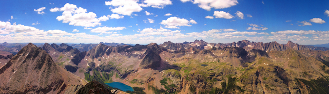
The San Juan Mountains span approximately 6,000 square miles in the southwestern portion of Colorado and contain several sub-ranges, including the Grenadier Range, Needle Mountains, West Needle Mountains, La Garita Mountains and the La Plata Mountains. The San Juans are home to some of the most rugged and breathtaking mountains in the continental United States.
The Danforth Hills rest north of Meeker Colorado, and are home to a collection of hills, none of which exceed 9,000 feet in elevation. These hills are home to several Native American relics leftover from the 19th century struggles between the Native Americans and early-American pioneers. The Meeker Historical Society has some writings concerning this area and period of time, which contained one of the most historical battles of that time-period: The Battle of Milk Creek.
The Sangre de Cristo Range spans over 180 miles from Colorado into New Mexico and is known by many locals for its solid congolmerate rock and its steep relief, rising out of the San Luis Valley. The festive town of Crestone sits at the base on the western side of the range and serves as a gateway to many of the lesser-known summits in the area. Another famous aspect of this mountain range is the Great Sand Dunes National Park, which rests at the western base of this range and can be seen from many of the summits of this range.
The Park Range is home to one of Colorado's most prominent peaks - Mount Zirkel. Although this range does not possess any summits over 12,180 feet, the area is home to many wonderful summits and the Mount Zirkel Wilderness Area. This range sits just south of Wyoming, northwest of Steamboat Springs. This range is roughly 40 miles long and rises steeply out of the Yampa River basin. Glaciation has left its distinctive mark of high valleys ending in rugged cirques. Over 150 miles of trails provide access and the wilderness area, which offers a variety of recreational opportunities including several quite difficult climbs.
The Elkhead Mountains are a relatively unknown and remote small mountain sub-range west of the Park Range near Steamboat Springs, Colorado. Due to the fact that this range is completely devoid of any summit over 11,000 ft., the opportunity for solitude is great. People rarely venture into this area of the state even though this range offers some great hiking experiences. According to Summitpost.org, most of the peaks in the Elkheads see very few ascents, but Hahns Peak, the eastern-most peak in the range, is a popular climb for residents of Steamboat Springs. Additionally, there are only three peaks within this range that have trails to the summit: Black Mountain, Sand Mountain, and Hahns Peak.
The Flat Tops are an elevated plateau resting in a large area just north of the I-70 corridor east of Grand Junction. This range is a massive block of rock pushed upward and planed level, its surface punctured here and there with rare peaks rising a thousand feet above the high plateau. (Quotation from A Hiking and Camping Guide to the Flat Tops Wilderness Area - Al Marlowe, Author)
The area comprises the second largest wilderness area of Colorado, the Flat Tops Wilderness Area. This wilderness are is 235,000 acres large and ranges between 7,600 ft. and 12,994 ft. in elevation. There are 160 miles of trails in this region and wonderful views of the surrounding plateau can be found atop the rare summits here. Due to the lack of 14,000 or 13,000 foot summits, this area offers wonderful solitude for summit climbers, especially on some of the lesser known summits. Some of the more popular summits in this area are Flat Top Mountain and Pyramid Peak.
The Medicine Bow Mountains are within the northwestern part of the Front Range and extend north into Wyoming. These mountains begin at the Diamond Peaks just west of Cameron Pass on Colorado State Highway 14 and extend north from there. Much of these mountains lies within the Rawah Wilderness Area, which entails 85 miles of trails over 73,068 acres. Summits in this range vary between 12,951 ft. (Clark Peak) and 10,000 ft.